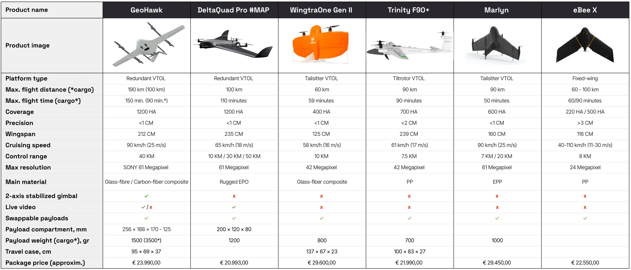
Key Differentiators in Mapping
Maximum Image Resolution
The maximum image resolution is a crucial factor for fixed-wing mapping UAVs. Resolution defines the level of detail visible in the captured images.
By focusing on these key differentiators, you can select a mapping UAV that not only meets but exceeds your operational and technical requirements.
High-resolution images provide superior detail, enabling more precise analysis of the subject matter. This is particularly advantageous for tasks requiring detailed post-processing, such as image analysis, object recognition, and 3D reconstruction. In disciplines like geography, surveying, and engineering, where precision is paramount, higher resolution directly contributes to more accurate outcomes.
Operating a drone at higher altitudes increases the coverage area per flight but typically reduces spatial resolution. To balance coverage and detail, a higher resolution camera is essential. This ensures that even at greater altitudes, the images captured contain sufficient detail per pixel, maintaining the overall quality and accuracy required for thorough analysis and effective data utilization.
Maximum
Flight Time
Maximum flight time is a pivotal parameter for mapping drones, significantly influencing the efficiency and effectiveness of mapping operations.
Extended flight durations allow the UAV to cover larger areas in a single sortie, minimizing the need for multiple flights and thereby potentially reducing the overall project timeline.
Furthermore, extended flight capabilities enable drones to function in remote or challenging locations where battery recharging or replacement might not be feasible, offering enhanced operational flexibility and adaptability in the field.
Higher altitudes may affect air density and aerodynamic performance.
Adverse wind conditions can increase energy consumption
Heavier payloads generally reduce flight duration.
The energy storage capacity directly correlates with flight endurance.
Understanding these variables is essential for optimizing drone operations and maximizing the effectiveness of your mapping missions
Maximum Mapping Area
The capacity of a mapping drone to survey extensive areas in a single flight is a critical factor in enhancing the efficiency and precision of the mapping process. Covering larger areas per flight reduces the necessity for multiple sorties, thus conserving time and resources. Additionally, the capability to survey broader regions facilitates the collection of more comprehensive data, which is invaluable for informed decision-making.
The surveying area is not a fixed parameter but is influenced by several factors, including camera resolution, cruise speed, endurance, and lens options. For a preliminary estimation of a drone’s potential coverage area, it is advisable to concentrate on resolution and maximum flight distance, which are two primary determinants.
To estimate the performance of various fixed-wing drones, we employ straightforward calculations. The values provided here are based on standard assumptions, such as a 3 cm per pixel resolution and a 50% image overlap, which are typical in mapping applications. It is important to note that the actual coverage area achieved in a specific project can vary due to factors like weather conditions, terrain, and the project’s unique requirements. For reference, 1 hectare is equivalent to 2.47 acres.

